Sanqingshan: Taoist Granite Peaks Guide
Sanqingshan, a UNESCO Taoist mountain of granite spires and clifftop plank walks. Tickets, cable cars, best season and how to reach it from Nanchang.
By Hello Nanchang · Last updated
Mount Sanqingshan, Yushan County, Shangrao, Jiangxi Province, China · Best Apr–Jun (azaleas) & Sep–Nov; sea of clouds at dawn; allow 1–2 days
At 4:40 in the morning the plank path is a queue of head-torches. Nobody talks much. You shuffle along a metre-wide walkway bolted to a granite wall with a few hundred metres of nothing underneath it, and the only sounds are boots on wet timber and somebody's thermos being unscrewed. Then the sky behind the ridge goes the colour of weak tea, the cloud lying in the valleys turns from grey to pink, and a rock pillar that everyone here calls the Giant Python lifts out of it. Twenty phones come up at once. It is, for about ninety seconds, completely worth the alarm.
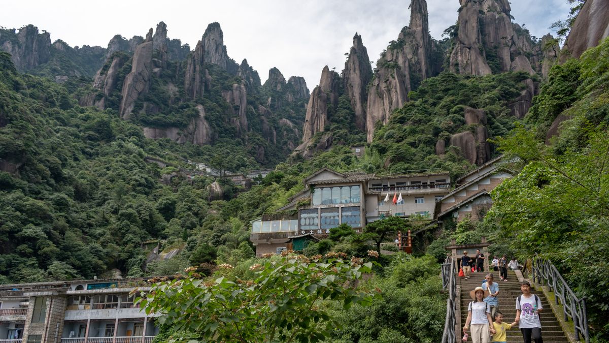
Sanqingshan (三清山, Mount Sanqing) is the most spectacular mountain in Jiangxi and, for foreign travellers, the least known good one in eastern China. It has Huangshan's granite drama — spires, pines, seas of cloud — at a fraction of Huangshan's traffic, and a Taoist history that goes back to a fourth-century alchemist. It was inscribed on the UNESCO World Heritage list in 2008 and made a Global Geopark after that. What it is not is a stroll: this is a mountain you earn on your feet.
Why Sanqingshan, and who it's for
The mountain is a forest of weathered granite pillars standing on a plateau around 1,500–1,600 m, with the highest, Yujing Peak (玉京峰), at 1,819.9 m. You don't climb it in the mountaineering sense — a cable car does the hard lifting — but once you're up there you spend your day on clifftop plank walkways (栈道) that traverse vertical rock, plus a lot of granite stairs between them. Its name means "Three Pure Ones," the highest deities of Taoism, and the summit plateau has been a Taoist site for well over a millennium.
It suits you if you can walk 10–15 km with stairs and you don't mind exposure. It does not suit you if heights genuinely frighten you, if your knees are unhappy on long descents, or if you were hoping for a temple-and-teahouse afternoon. For that, go to Longhushan instead — same province, same Taoist tradition, about a tenth of the effort.
South or East? The decision that shapes your day
This is the single most important thing to get right, and most English-language write-ups skip it. Sanqingshan has two main base areas on opposite sides of the massif, each with its own gate and its own cable car:
- East — Jinsha service area (金沙服务区), with the Jinsha cableway: about 2,670 m of cable, roughly a 10-minute ride. You come off it a short walk from the entrance to the Sunshine Coast (阳光海岸) plank walk, and closer to the Goddess and Giant Python end of the mountain.
- South — Waishuangxi service area (外双溪服务区), with the Waishuangxi cableway: a similar 8–10 minutes up. It lands you at the Tianmen Peaks end, near the Rishang Shanzhuang lodge, and it's the more natural side if the West Coast (西海岸) promenade is your priority — around an hour's walk west once you're up.
Two things follow from that. First, the scenery is not a choice between good and better — the top is a loop, and from either side you can reach the famous formations if you have the legs. Second, and this is the trap: the two base areas are linked only by the long ring road around the mountain. Going up one side and down the other means your luggage, your car and your onward bus are all on the wrong side. Unless you've deliberately arranged a transfer, plan to come down the way you went up.
There are also two smaller entrances — Yulingguan in the east and Fenshui in the north — but almost every visitor uses Jinsha or Waishuangxi. Whichever one your bus, ticket or hotel booking refers to, write it down and check it twice.
Getting there from Nanchang
Here's the honest version: no train reaches the mountain. You take a high-speed train to the gateway town and transfer by bus or taxi. It's simple once you know the shape of it.
- Train to Yushan South (玉山南). From Nanchang, high-speed services run east to Yushan on the Shanghai–Kunming corridor; most leave from Nanchang West and take roughly 2 to 2.5 hours. Check the timing of your specific train, and see our Jiangxi by train guide and Nanchang stations guide for the departure end.
- Transfer to a base area — about 55 km, and this is the fiddly bit. In season a tourist shuttle runs from the high-speed station to the scenic area in roughly an hour for about ¥20–30. When it isn't running, the reliable fallback is to get into Yushan town and take a scheduled coach from Yushan bus station (玉山汽车站): there are services to both the east (Jinsha) and south (Waishuangxi) base areas, generally around ¥14–17, roughly every 40 minutes from early morning until about 5pm, taking about 80 minutes. A taxi or Didi direct from the station is about ¥150–160 and worth splitting between three or four people.
- Up the mountain. Buy your gate ticket and cable-car ticket at the base area and ride up.
Coming from elsewhere in the region: Shangrao (上饶) is the other gateway, with coaches to the south side from the Daihu Road bus station — historically just a couple a day, around mid-morning and early afternoon, so check the timetable before you commit. If you're chaining this with the villages, Wuyuan connects through Shangrao too; the 5-to-7-day Jiangxi loop sequences the whole thing.
Tickets, cable cars and hours
- Gate ticket: around ¥120 for adults. Students and visitors aged 60–64 are typically half price (about ¥60); over-65s and children under 1.2 m usually free. Bands are re-announced yearly — bring ID.
- Cable car: about ¥70 up, ¥55 down, ¥125 return, the same on both cableways. Almost everyone rides. Walking up is a multi-hour stair grind that will cost you the good light.
- Hours: roughly 7:30am–5:30pm on ordinary days, extending to about 7:00am–6:00pm on public holidays. The detail that catches people out is the last cable car down — commonly around 5:30pm in peak season and as early as 4:30pm off-season. Miss it and you are walking.
- Booking: tickets are sold through the scenic area's own WeChat account and mini-program as well as the big Chinese travel apps, and entry is normally by ID/passport scan. Book the night before in high season.
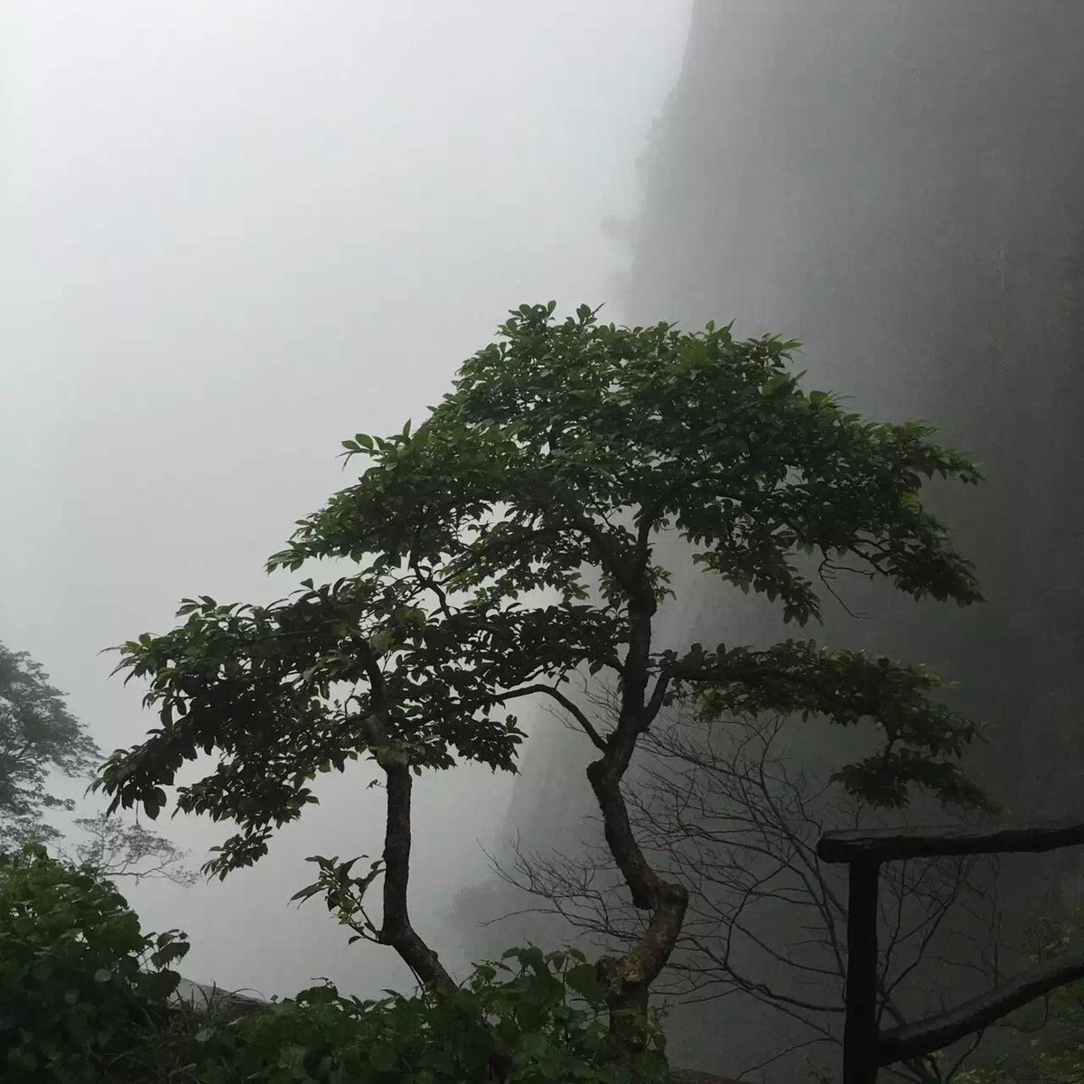
The kind of rock face the plank walkways are pinned to. From below they're invisible; from on them, the drop is the whole point. · Photo: Huangdan2060 / CC0 public domain via Wikimedia Commons
The four zones, and the two great plank walks
Once you're on top, Sanqingshan divides into four areas linked by walkways. Knowing what each one is stops you wandering.
- Nanqingyuan (南清园) — the headline formations. A circuit taking in Giant Python Rising (巨蟒出山), a 100-metre-plus stone column that really does look like a snake standing on its tail, and the Goddess of Spring (司春女神), a seated female profile in the rock. Also the "Thread of Sky" crevice stair. Steepest and busiest zone; allow 2–3 hours.
- West Coast (西海岸) — the level one. A cliff promenade running about 4 km at an average 1,600 m, of which roughly 3,600 m has no steps at all. This is the single best thing on the mountain for anyone worried about stairs: it is long, flat, and hangs over the biggest views. Cloud, when it comes, arrives here first.
- Sunshine Coast (阳光海岸) — the east gallery. About 3,600 m of walkway on the eastern face at similar altitude, facing the sunrise. Less trafficked than Nanqingyuan and the natural first move if you came up the Jinsha cableway.
- Sanqing Palace (三清宫) and Yujing Peak (玉京峰). The quiet, high, historical corner: Ming-dynasty stone halls, old altars, and a slog up to the 1,819.9 m summit for those who want it. Fewest people, most atmosphere.
A comfortable one-day plan is: cable car up → one coast walk → Nanqingyuan → back to the cable car. A two-day plan adds the other coast and the Sanqing Palace area, with a night on top for the sunrise.
How hard is it, really?
Expect 6–9 hours of walking and 10–15 km for a proper day up top, most of it on engineered surfaces. There is no scrambling and no exposure without a railing. What there is:
- Stairs. Thousands of them. The Nanqingyuan circuit in particular is a sustained up-and-down of granite steps, some of them steep and narrow. Descending is harder on the knees than climbing; poles help.
- Exposure. The plank walks are wide enough and fully railed, but they are cantilevered off vertical rock with a long drop below. If you have real vertigo, you will not enjoy them — and that's not a character flaw, it's a reason to build your day around the Sanqing Palace zone instead.
- Weather. Wet timber is slippery, cloud can cut visibility to nothing, and walkways close in high wind, storms or ice — most likely in winter. Grippy shoes are not optional; a windproof layer is sensible even in summer, because it is markedly colder and windier up top than at the gate.
- The step-free workaround. If someone in your group can't do stairs, put them on the West Coast promenade with a book and a view and let the rest of the group do Nanqingyuan. It genuinely works.
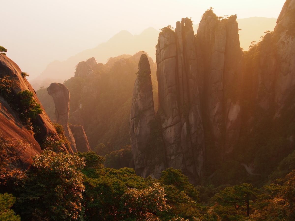
Giant Python Rising at first light — the mountain's signature silhouette, and the reason people set alarms for 4am. · Photo: Dcpeets / CC BY-SA 4.0 via Wikimedia Commons
Sunrise: where to stand, and when to get up
The dawn cloud sea is the reason to sleep on the mountain, and it is a gamble — some mornings the valleys fill with white and the peaks float; some mornings you get flat fog and see nothing at all. Play the odds and enjoy the walk regardless.
- Yutai (玉台) is the most popular sunrise platform: open, wide, and about 20–40 minutes' walk from the Goddess Hotel area on the east side. This is where most people go, and where the tripods line up.
- Ziyanshi (紫烟石), by the Sanqing Palace management station, is around 5 minutes from the door if you're staying up there — the low-effort option.
- Yujing Peak is roughly 40 minutes above the Sanqing Palace area, for people who want the summit at dawn and don't mind climbing in the dark.
- Sunshine Coast faces east by definition, but reaching a good spot on it takes over an hour — start very early or pick something closer.
Sunrise itself swings enormously with the season: roughly 4:40–5:30am at midsummer, around 5:30–6:00am in autumn, and as late as 6:30–7:00am in deep winter. In summer that means an alarm at 4:00–4:30. Ask your hotel reception the night before — they track it daily and will tell you both the time and whether the forecast is worth the sleep. Bring a head-torch; the walkways have limited lighting.
Sleeping on the mountain vs coming up for the day
Stay up top if the sunrise matters to you. That's the whole calculation. There is no cable car early enough to get you to a viewpoint for dawn, so a day visitor simply cannot see it.
What staying up top actually involves:
- A handful of lodges, all of them a seller's market. On the east side, the Goddess Hotel (女神宾馆) is the closest to the Yutai sunrise platform and priced accordingly; Jumang Shanzhuang (巨蟒山庄) is a plainer option about 20 minutes from the Jinsha cable-car top. On the south side, Rishang Shanzhuang (日上山庄) sits around 20 minutes from the Waishuangxi cable-car top. Mountain lodges here open, close and change hands — confirm yours is trading before you build a sunrise plan around it.
- Rates swing wildly — roughly ¥300–600 for a simple twin at the plainer lodges, and well north of ¥1,000 for the best-positioned rooms in peak season and at weekends. Everything here was carried up by porter or cable car, which is the honest explanation for the pricing.
- Manage expectations on comfort. Some mountain lodges supply hot water only during set evening hours, heating can be limited, and rooms are basic. Book well ahead for May–June, October and any public holiday.
- Travel light. Take a day pack up and leave the main bag at your base-area hotel or in station lockers. Porters exist, and they charge.
Come up for the day instead if you're on a tight loop, travelling with kids, or the forecast is bad. Sleep in Yushan town or at a base-area guesthouse, take the first cable car, walk one coast plus Nanqingyuan, and be down by mid-afternoon. You'll miss the dawn and see nearly everything else.
What to eat — and what to carry up
Food on the summit is expensive, and reasonably so: every noodle was carried up. Budget roughly ¥15–40 for breakfast and ¥40–60 a head for lunch or dinner at the mountain-top restaurants. A bowl of plain noodles runs around ¥35–40, a two-vegetables-and-a-meat set meal around ¥35–45, instant noodles around ¥15. Down at the base areas, farmhouse restaurants (农家乐) do a full meal for more like ¥20–30 a head.
So: buy your day's supplies at the bottom. Two litres of water per person, bread, fruit, chocolate, and something salty. Then eat properly when you're back down.
- Yushan cured duck (三清山腊鸭) — the local speciality: free-range river duck salted for about three days and sun-dried for seven, then steamed or stir-fried. Lean, chewy, intensely savoury. Dinner dish, roughly ¥50–90, and the thing to order if you order one thing.
- Red mushroom soup (红菇汤) — wild crimson mushrooms from the mountain forests simmered with chicken. Comes out deep pink and tastes like the woods. Seasonal and not cheap; ask what's fresh.
- Bracken shoots and mountain greens (蕨菜 / 高山野菜) — stir-fried with garlic or cured pork, a few tens of yuan, and a good balance to a heavy table. Ask 少辣 (shǎo là) if you want it mild; Jiangxi is a chilli province and Shangrao is no exception.
- Free-range chicken soup (土鸡汤) — a clear, long-simmered pot, usually shared, ¥80–150. What people order after a long day on stairs.
- High-mountain cloud-mist tea (高山云雾茶) — grown on these slopes, sold everywhere, and the easiest edible souvenir to carry home.
We're not naming individual restaurants: the base-area strip turns over constantly. Pick the one with local number plates outside at 1pm.
Best time to visit
The mountain is at its best in the shoulder seasons — April to June and September to November — when days are mild (roughly 15–25°C up high) and clear spells are more reliable.
- Late spring (May–June): the standout. Slopes of ancient alpine azaleas, some from trees centuries old, layer pink and red across the ridges, and morning cloud seas are frequent. The photographers' pick.
- Autumn (September–November): crisp, clear, comfortable, and the best long-range visibility of the year.
- Summer (July–August): a cool escape from the lowland heat, but the busiest period and prone to violent afternoon thunderstorms — which close walkways.
- Winter: cold, sometimes icy, and almost empty; granite spires under rime ice are extraordinary. Check that the plank paths are open before you commit to the journey.
The alchemist, the abbot, and the emperor who vanished
Sanqingshan's Taoist story starts in the Eastern Jin, around 357–361 CE, when the alchemist and physician Ge Hong (葛洪) is said to have built a hut on the mountain and set up a furnace. He's counted as the mountain's founding figure, and the summit plateau still has a well and a furnace site attributed to him.
The buildings you see are much later. In the Ming Jingtai era a Taoist named Wang You (王祐) set out to rebuild the Sanqing Palace properly and brought in a monk from Zhejiang, Zhan Biyun (詹碧云), to plan it — and Zhan laid the whole summit complex out on the pattern of the eight trigrams, with halls, altars, gates and paths positioned as points on a giant diagram spread across the mountaintop. It is one of the more remarkable pieces of landscape design in Chinese religious architecture, and you walk through it without noticing unless someone tells you.
Then there's the tomb. In the southeast corner of the summit area sits a Ming grave whose stone reads "the place where Zhan Biyun stores bamboo." Bamboo — zhú — is a homophone for Zhū, the surname of the Ming imperial house. A carving beside it uses a character meaning "small serpent," which matches the zodiac year of the Jianwen Emperor, the young ruler who disappeared in 1402 when his uncle seized the throne and whose fate is one of the great unsolved questions of Chinese history. Some researchers have argued the monk was the emperor and this is his grave. It is not settled, and it may never be. It is a very good thing to think about on a quiet path at 1,600 metres.
What to skip, and other honest notes
- Don't plan to go up one cableway and down the other unless you have transport arranged. The ring road is long and you will strand yourself and your bags.
- Don't bank on the sea of clouds. Treat it as a bonus. If a clear-and-dry forecast is what you get, that's still a superb day of rock and long views.
- Don't come on the first days of the May or October national holidays. Cable-car queues can eat hours, and the Nanqingyuan stairs turn into a single-file shuffle.
- Don't underestimate the last cable car. Off-season it can be as early as 4:30pm. Set an alarm on your phone for the turnaround time.
- Don't compare it to Wugongshan. If it's rolling green grassland and camping you want, that's Wugongshan, in the west of the province. Sanqingshan is vertical rock. Lushan is a third thing again — a cool-climate hill station with villas and waterfalls.
- English is scarce. Signage on the walkways is bilingual in places, but staff, drivers and lodge receptions mostly aren't. Download offline maps and a translation app, and set up Alipay or WeChat Pay before you arrive.
Practical info
- Getting there: HSR Nanchang (mostly Nanchang West) → Yushan South (玉山南), about 2–2.5 hours; then shuttle/coach (~1 hour to 80 min, ~¥14–30) or taxi (~¥150–160) to the Jinsha (east) or Waishuangxi (south) base area, about 55 km.
- How long: one long day for the highlights; two days with a night on top if you want sunrise.
- Tickets: gate around ¥120 (concessions about ¥60); cable car about ¥70 up / ¥55 down / ¥125 return.
- Hours: roughly 7:30am–5:30pm, about 7:00am–6:00pm on public holidays; last cable car down ~5:30pm in peak season, as early as ~4:30pm off-season.
- Bring: grippy shoes, windproof layer, head-torch for sunrise, water and snacks bought at the bottom, poles if your knees want them.
- Good for: hikers, photographers, anyone who liked Huangshan and wants it quieter.
- Less good for: vertigo sufferers, weak knees, wheelchair users (the West Coast promenade is the only broadly level section), and anyone on a rigid schedule in bad weather.
Sanqingshan FAQ
Is Sanqingshan worth visiting?
If you like mountains, it's the best day in Jiangxi. Granite spires, kilometres of cliff walkway, a summit laid out as an eight-trigram diagram, and far fewer people than any comparable Chinese mountain. If you don't like stairs or heights, be honest with yourself — it will be a long day.
Should I use the East (Jinsha) or South (Waishuangxi) cable car?
East/Jinsha if you want to start on the Sunshine Coast walkway and be nearer the Goddess and Python formations. South/Waishuangxi if the West Coast promenade is your priority. The views from both are comparable — the real deciding factors are which base area your transport and hotel are on, and the fact that you should come down the way you went up.
Do I need to stay overnight on the mountain?
Only for sunrise — and that's a real reason, because no cable car runs early enough for a day visitor to reach a viewpoint at dawn. Otherwise a well-organised single day covers the headline scenery comfortably.
When do the azaleas bloom?
Usually May into June, but the peak moves with the year's weather. If you're travelling specifically for it, check a current local update a week or two out rather than booking off a fixed date.
How does Sanqingshan fit with the rest of Jiangxi?
It's the mountain leg of the province's classic northeastern circuit: Nanchang → Jingdezhen for porcelain → Wuyuan for the villages → Sanqingshan for the peaks. That's exactly the shape of our 5-to-7-day Jiangxi loop; Longhushan adds easily onto the same eastern corridor. More options in Destinations.
Quick tips
- No train reaches the mountain — build the Yushan → base area transfer (about an hour, sometimes 80 minutes) into your day.
- Take the cable car; walking up costs hours you'd rather spend on the walkways.
- Confirm which base area your bus, ticket and hotel refer to — the two sides are a long drive apart.
- Check the last cable car time on arrival and set a phone alarm for your turnaround.
- Buy water and snacks at the bottom; summit prices are several times base prices.
- Grippy shoes, a windproof layer, and a head-torch if you're chasing sunrise.
- Passport for the train and the gate; Alipay or WeChat Pay for everything else.
Want the mountain slotted into a route that also gets you kilns, villages and a river city — at a pace that suits your legs? Plan a custom Jiangxi trip with us.
Images: "19190-SanQingShan" by Xiquinho Silva (CC BY 2.0); "Cliffs of Sanqing Mountain" by Huangdan2060 (CC0 / public domain); "Sanqingshan sunrise python" by Dcpeets (CC BY-SA 4.0) — all via Wikimedia Commons.
Last verified: 2026-08. Train times, fares, ticket and cable-car prices, bus timetables, opening hours, last-cable-car times and plank-path closures change often — please double-check official sources before you travel.
You Might Also Like
- Lushan (Mount Lu): China's Summer Escape
- Nanchang Travel Guide: Jiangxi's Capital
- Poyang Lake Nature Reserve: See the Cranes
Explore Nanchang & Jiangxi itineraries · Plan a custom trip with us