Nanchang's City Origin Point: Standing on Bayi Square's Centre
Bayi Square is Nanchang's living room and its official City Origin Point. What the bronze marker means, the granite monument, and how to do the square right.
By Chen · Hello Nanchang · Last updated
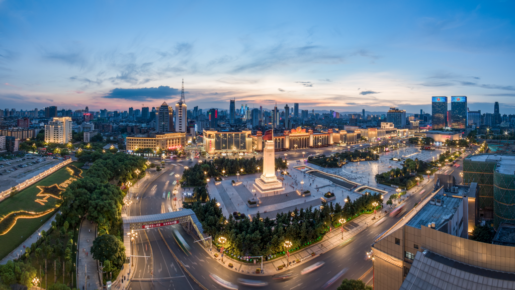
Stand in the middle of Bayi Square (八一广场) at dusk and you're standing on the exact spot the city now calls its own dead centre — Nanchang's official City Origin Point, the point from which, on paper, the whole city is measured. To the south, a granite spire lifts a stone rifle against the sky. To the west, a heavy 1960s hall wears a giant red star that switches on after dark. Skateboarders clatter past retired couples ballroom-dancing to a portable speaker, a vendor's balloons tug at their strings, and the fountains come up out of the granite like the square is exhaling. Most travellers cross here in ten minutes on the way to somewhere else. Give it an hour, and it turns into the single best place to read the whole city at once.
This is Nanchang's living room and its history lesson, folded into one flat expanse of stone in the heart of the old town. You don't need a ticket, you don't need to book, and Metro Lines 1 and 2 both surface right underneath it. Here's what the square actually is, why the city planted its geographic zero point right in the centre circle, why a granite obelisk became Nanchang's face, and how "八一" — two characters, "eight-one" — ended up stamped on half the road signs in town.
The City Origin Point — the marker you're meant to stand on
Start with the detail almost no visitor knows about, because it reframes everything else on the square. In September 2025, Nanchang's municipal people's-congress standing committee formally designated the centre circle of Bayi Square — the point where the square's north–south axis crosses the line of Beijing West Road (北京西路) — as Nanchang's official City Origin Point (南昌市城市原点). On 11 November 2025 the physical marker was unveiled on the spot. Stand on it and you're standing on the point the city has chosen to call the middle of itself — the notional zero from which every distance counts out.
An "origin point" (原点) is a city's geodetic anchor: a fixed reference the authorities use for planning, engineering and mapmaking, the spot the map is laid out from. If the idea sounds abstract, think of Beijing's "Zero Point of Highways," the bronze medallion set into the pavement by Qianmen from which China measures its road distances — same principle, city-scale. Plenty of Chinese cities have picked one; Nanchang, fittingly, put its dead centre in the middle of the square that has been the city's centre of gravity for seventy years.
What's genuinely nice is that the choice was put to a public vote. In July 2025 the planning bureau shortlisted five candidate spots across three landmarks — this square, Tengwang Pavilion (滕王阁) and the Qiushui Square fountain (秋水广场) — and opened an online ballot. The centre of Bayi Square won in a landslide, taking a reported 81.73% of the vote — a figure that lands with a wink, given the square is named for "eight-one."
The marker itself rewards a proper look, because it's a small map of the city and the province rolled into one bronze disc. It's a circular bronze relief, about 2.7 metres across, laid into the granite and built in three concentric rings, each carrying a different layer of meaning:
- The outer ring is the geography. It's marked with the compass directions in Roman letters — with N pointing straight at the flag-raising terrace and S pointing at the uprising monument — and it carries the point's precise coordinates: roughly 28°40′38″ N, 115°53′59″ E. The border is worked in yúnléiwén (云雷纹), the ancient cloud-and-thunder scroll pattern you see on Bronze Age ritual vessels.
- The middle ring is the history. It nods to the city's founding — the Han-dynasty general Guan Ying (灌婴), sent to build a walled town here in 202 BC, which is where Nanchang's two-thousand-plus years begin.
- The inner ring is the landscape. A relief of the "Gan-Poyang land" (赣鄱大地) fans out from the centre — Meiling in the near view, Poyang Lake in the middle distance, Lushan far off — rendered in the blue-green style of the Song masterpiece A Thousand Li of Rivers and Mountains and the ink landscapes of Jiangxi's own Fu Baoshi.
So when you crouch to read it, you're reading the city outward from its own middle: bronze-age pattern, Han-dynasty founding, the mountains and lake that ring the modern city. Almost nobody visiting knows the disc is there, which is exactly why it's fun to find it, stand on the centre, and take the photo looking straight down. It's the most low-key "you are here" in the whole city.
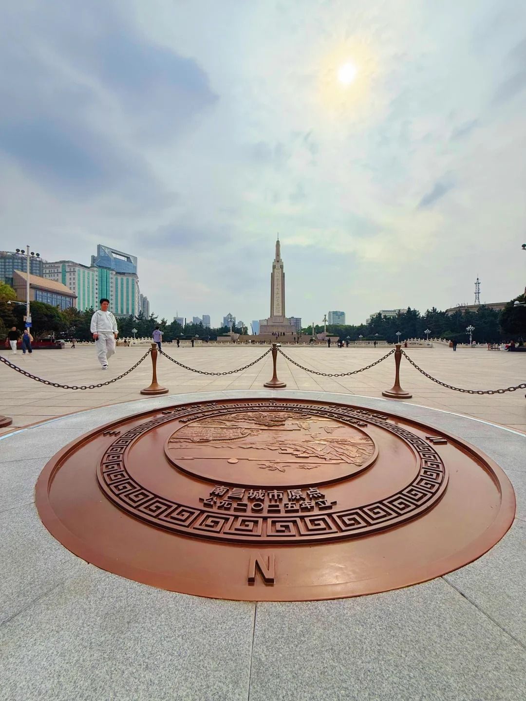 The City Origin Point disc itself — three bronze rings (compass and coordinates on the outside, the city's founding, the Gan-Poyang landscape at the centre), with the monument standing on the square's axis behind. © Hello Nanchang.
A drill ground that became a city's centre of gravity
The ground under your feet has been open and important for a very long time. Under the Qing dynasty this was a 大校场 — a large military drill field where new recruits were trained — and in the Republican decades it stayed martial, a stretch of army barracks on the edge of the walled town. The city kept it open, and in 1952 the young People's Republic formally laid it out as a civic plaza and named it People's Square (人民广场).
The name it carries today came later. In 1977, to mark the 50th anniversary of the events of 1927 (more on those in a moment), the square was renamed Bayi Square — "August-First Square." Then, between 2001 and 2004, the city gave it the wholesale rebuild that produced the square you see now: the central monument was physically raised, a shallow "Golden Water" canal (金水河) and a music-fountain system were laid into the granite, a run of carved military-history reliefs and a flag-raising terrace were added, and the plaza was pushed out to somewhere around 78,000 square metres (local accounts of the exact figure vary, and it's often described as one of the largest urban squares in this part of China — long said to rank second only to Tiananmen). What was a drill ground for one dynasty's soldiers is now the flat, floodlit stage where the whole city comes out to walk in the evening.
The rhythm is worth catching. Early morning belongs to the tai-chi practitioners and the people power-walking laps before the heat lands. Midday it empties out under the sun. Then, from about seven, it fills again: dance circles forming around a single loud speaker, kids on scooters and light-up sneakers, grandparents flying oversized kites off the open granite, couples photographing the lit obelisk, and a loose crowd drifting to the fountain at the south end. There is no daily flag ceremony at a fixed hour; the big flag-raisings happen on national dates like Army Day (1 August) and National Day, when the square fills hours before dawn. On an ordinary Tuesday night, what you get instead is a city relaxing in public — the guǎngchǎngwǔ (广场舞) dance aunties, the balloon sellers, the retired men playing cards under a lamp — which is arguably the better show.
The August 1st Uprising Monument — reading the spire
The tall granite spire at the south end is the Monument to the August 1st Nanchang Uprising (八一南昌起义纪念塔), and it is the single object that put Nanchang's face on the map. It's worth understanding as a piece of design and as a piece of the city's story — which is what it is, regardless of how you feel about the politics attached to it.
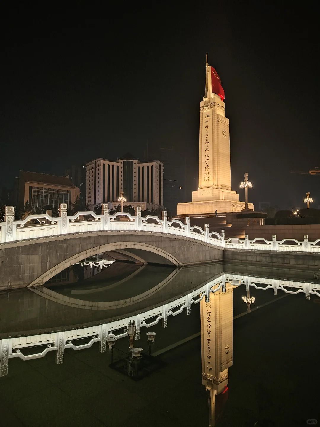 The obelisk at night, mirrored in the Golden Water canal beside the arched marble bridge — the frame everyone comes for. © Hello Nanchang.
The history it marks is specific and, honestly, dramatic. Before dawn on 1 August 1927, in the wreckage of a collapsed alliance between China's two great political parties, a group of military commanders launched an armed uprising in Nanchang and, after a few hours of street fighting, briefly took the city. They couldn't hold it — they marched south within days and were scattered — but the date stuck. Modern China dates the founding of its army to that morning, which is why the country observes 1 August as Army Day, and why Nanchang calls itself "the city where the army's flag first rose." Whatever your view of what came after, 1 August 1927 is the hinge on which this particular city's identity turns.
Now look up at the spire and read it, because every part of it is deliberate:
- The height is a number, not an accident. The monument first went up for the uprising's 50th anniversary — construction began on 1 August 1977 and finished on 8 January 1979 — and originally stood about 45.5 metres. During the 2001–2004 rebuild it was raised, on the spot, by exactly 8.1 metres — a nod to "eight-one" — to its present height of 53.6 metres. The whole thing reads bottom to top as a platform base, a broad plinth, the tapering shaft and the crowning sculpture.
- The base plinth is dated in stone. The step below the shaft is carved with "1927·8·1," so the founding date sits at eye level before your gaze even travels up.
- The top is a rifle and a flag. Crowning the spire is a stone carving of an upright "Hanyang-made" rifle (汉阳造, the bolt-action rifle the uprising's soldiers actually carried) standing behind a red granite rendering of the army flag with its gilded star-and-八一 emblem — a monument to a beginning, told in the tools of the moment. It's the red splash you can read from across the square, and floodlights hold it after dark.
- The sides tell the story in relief. Around the plinth run large carved panels — declaring the uprising, storming the enemy camp, celebrating the victory — waist-high figures you can walk right up to.
- The calligraphy is signed. The nine gilded characters reading 八一南昌起义纪念塔 down the north face were written by Ye Jianying (叶剑英), who was himself one of the 1927 commanders — a small, real link between the man and the marker.
Photograph it from the broad south plaza at dusk, when the granite goes warm against a darkening sky and the fountains throw reflections across the wet stone; the arched marble bridge over the Golden Water canal gives you a foreground and a mirror image in one frame. If you want the calligraphy and the relief panels sharp, come in daylight and shoot from the base looking up. Either way it's the shot that says "Nanchang" more than any other.
 By day you can read the whole spire — the red flag and stone rifle up top, Ye Jianying's gilded calligraphy down the shaft, and a relief panel at the base. Photo: Heihaheihaha / Wikimedia Commons (CC BY 4.0).
The "八一" you'll see everywhere — one date, a whole map
Once you've registered that "八一" means "August 1st," you start seeing it all over the city, and it stops looking like decoration and starts looking like a signature. The date is threaded through Nanchang's whole geography:
- Bayi Avenue (八一大道) — the wide central spine that runs past the square, one of the city's main arteries.
- Bayi Bridge (八一大桥) — a cable-stayed crossing over the Gan River (赣江), its twin pylons and cables lit at night, best seen glowing from the Honggutan waterfront.
- Bayi Park (八一公园) — a leafy lake park a short walk from the square, built around a slice of the old East Lake, good for a twenty-minute breather among willows, pavilions, tai-chi and pedal boats.
- Bayi Football (八一队) and countless shops, schools and a whole brand of local pride — you'll spot the two characters on signage long after you've stopped counting.
- The August 1st Uprising Memorial Hall (八一南昌起义纪念馆) — the museum in the former Jiangxi Grand Hotel, a few minutes' walk off the square, where the commanders set up their headquarters in 1927. (It's a deeper stop in its own right — worth a separate visit if the history grabs you.)
Learn to spot those two characters and the city map suddenly reads like a sentence. The square is simply the capital letter at the front of it.
What else rings the square
Bayi Square isn't just the monument and the open stone. The buildings around its edges are a compact cross-section of the city's cultural life, and a couple of them reward a closer look.
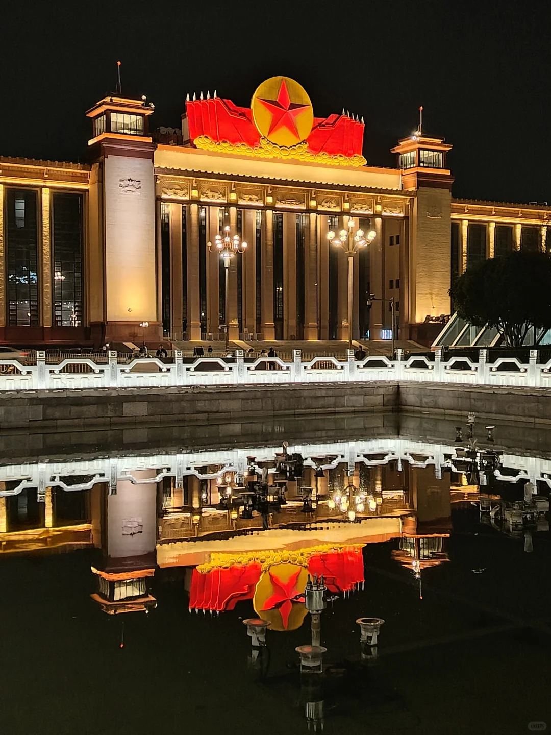 The red-star hall on the west side — the 1968 "Long Live Hall," now the Jiangxi Provincial Art Museum, and the square's most photogenic backdrop after dark. © Hello Nanchang.
The Jiangxi Provincial Art Museum (江西省美术馆) — the hall with the red star. The monumental building on the west side, the one wearing the illuminated red star that glows over the square at night, has an unusually layered past. It went up in 1968 as the "Long Live Hall" (万岁馆) — a grand, symmetrical, mountain-shaped pile that was one of Nanchang's ten major buildings of its era and a provincial landmark. Over the decades it served as an exhibition hall and revolutionary museum, became the Jiangxi Provincial Exhibition Center in 1992, and in 2020 was given over to the Jiangxi Provincial Art Museum. Same bones, new purpose. It leans toward Chinese ink painting, calligraphy and provincial-art shows, admission is usually free, and it works on real-name registration — bring your passport. Even if you don't go in for a show, it's the square's most photogenic backdrop after dark: that red star, the floodlit colonnade, and the whole thing mirrored in the canal.
Nanchang Book City (南昌书城) — the Xinhua Bookstore, reborn. Across the square's edge sits the city's flagship Xinhua Bookstore, rebuilt into a cultural complex that opened around 2022. It runs to roughly 36,000 square metres over five above-ground floors, houses what's billed as Jiangxi's first 24-hour bookstore (a lit reading room that stays open through the night), and keeps a dedicated section on Gan (Jiangxi) culture and local authors — a good place to pick up a bilingual map or a picture book of Tengwang Pavilion. It's a genuinely pleasant, air-conditioned refuge to sit out a downpour or the midday heat, with cafés and reading nooks on the upper floors and windows that look back over the square.
The Army Museum, rising to the south. On the blocks immediately south of Bayi Square, a major new Army Museum — long planned for the city that calls itself the army's birthplace — has been taking shape, with clearance and building work visibly under way in recent years. It isn't open yet, and completion dates for a project this size move around, so treat it as a "watch this space" rather than a stop — when it opens we'll give it its own guide.
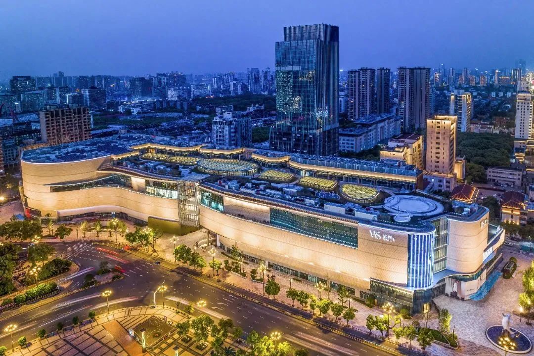
Wushang MALL, right across the way. The gleaming retail block on the square's edge is Wushang MALL (武商MALL), Jiangxi's first true luxury mall — useful less for the handbags than for being the cleanest, coldest, most card-friendly building within a two-minute walk when you need a bathroom, a coffee, or air-conditioning. If shopping is on your list, we've written the full guide separately: Wushang MALL, Nanchang's luxury address.
 Wushang MALL on the square's edge — your nearest reliable air-con, bathroom and coffee, and Jiangxi's first luxury mall. © Hello Nanchang.
How to do it well — and how long to give it
Bayi Square is best treated as the anchor for a downtown half-day on foot rather than a destination in itself. Here's a simple way to string it together:
- Come up from Bayi Square Station. Lines 1 and 2 interchange directly under the square, and the exits open onto its edges — you surface already there, no walk required.
- Find the City Origin Point first. Head to the central circle on the square's north–south axis, stand on the bronze disc, read the three rings (geography, founding, the province's mountains and lake), and take the looking-down shot before the evening crowd thickens.
- Walk to the monument. Read the spire — the "1927·8·1" plinth, the rifle and flag up top, the 8.1-metre detail, Ye Jianying's calligraphy — and circle the relief panels at the base.
- Photograph at dusk. The south plaza, looking at the lit obelisk with the arched bridge in the foreground, is the money shot; the red-star hall on the west side is the second-best frame once it's dark.
- Loop the edges. The art museum, Nanchang Book City, Wushang MALL and Bayi Park are all within a few minutes — dip into whichever fits your day and the weather.
- Walk on to the river. Head roughly 1.5 km west (about 15–20 minutes on foot, or one metro hop) and you reach Tengwang Pavilion on the Gan River — ideally timed for golden hour and the evening light show across the water.
Give the square itself 30–60 minutes. Add an hour or more if you go into the art museum or the bookstore, and build in a whole downtown afternoon if you're chaining it to Tengwang Pavilion and the old-town lanes beyond.
Practical notes
- Getting there: Metro Line 1 / Line 2 to Bayi Square Station (八一广场站), exits directly onto the square. By taxi or DiDi, show the driver 八一广场.
- Cost & hours: the square is free and open around the clock; nothing to book. The surrounding art museum, bookstore and nearby memorial hall keep their own hours — confirm current opening times and any reservation rules before you go, as these change.
- Best time: early morning for quiet, kites and tai-chi; dusk into evening for the fountains, the lit monument and the local crowd. Summer middays are brutally hot and humid — carry water and shade.
- Pay & language: WeChat Pay and Alipay run everything nearby, both now workable for foreign visitors via their tourist mini-programs; metro and street signage is bilingual. Bring your passport if you plan to enter any of the museums, which use real-name registration.
- Good for: first-timers getting their bearings, history-minded travellers, evening photographers, families. Less good for: anyone hoping for shade at noon, or expecting a ticketed "attraction" — this is a public square, and its pleasure is in the atmosphere, not a turnstile.
Nanchang isn't a city that hands over its story on a plaque. But stand on that centre circle at dusk — the bronze disc under your shoes, the granite spire on one side, the red star on the other, the fountains breathing in the dark — and you're standing on the exact point the city has chosen to call its middle: the drill ground turned living room, the date turned map, the place everything else in town is measured out from.
Planning a downtown day around the square, Tengwang Pavilion and the old-town lanes? Tell us what you like and we'll build the route for you — plan your Nanchang trip with us.
Last verified: 2026-07 — historical dates, building status and opening details change over time; please double-check current information and official sources before you travel.